The Annapurna Base Camp trek is one of Nepal’s most beloved hiking adventures, offering trekkers a chance to walk through lush rhododendron forests, traditional Gurung and Magar villages, and dramatic mountain amphitheaters. Before you lace up your boots, though, it is important to understand the Annapurna Base Camp trek elevation profile. Knowing how the altitude changes day by day helps you prepare physically, pack appropriately, and avoid the common pitfalls that catch unprepared trekkers off guard.
In this guide, we break down everything you need to know about the elevation profile, along with related details like Annapurna Base Camp elevation gain, trek distance, difficulty, and safety concerns such as altitude sickness. By the end, you will have a clear roadmap for what lies ahead on this unforgettable journey.
Understanding the Annapurna Base Camp Trek Elevation Profile
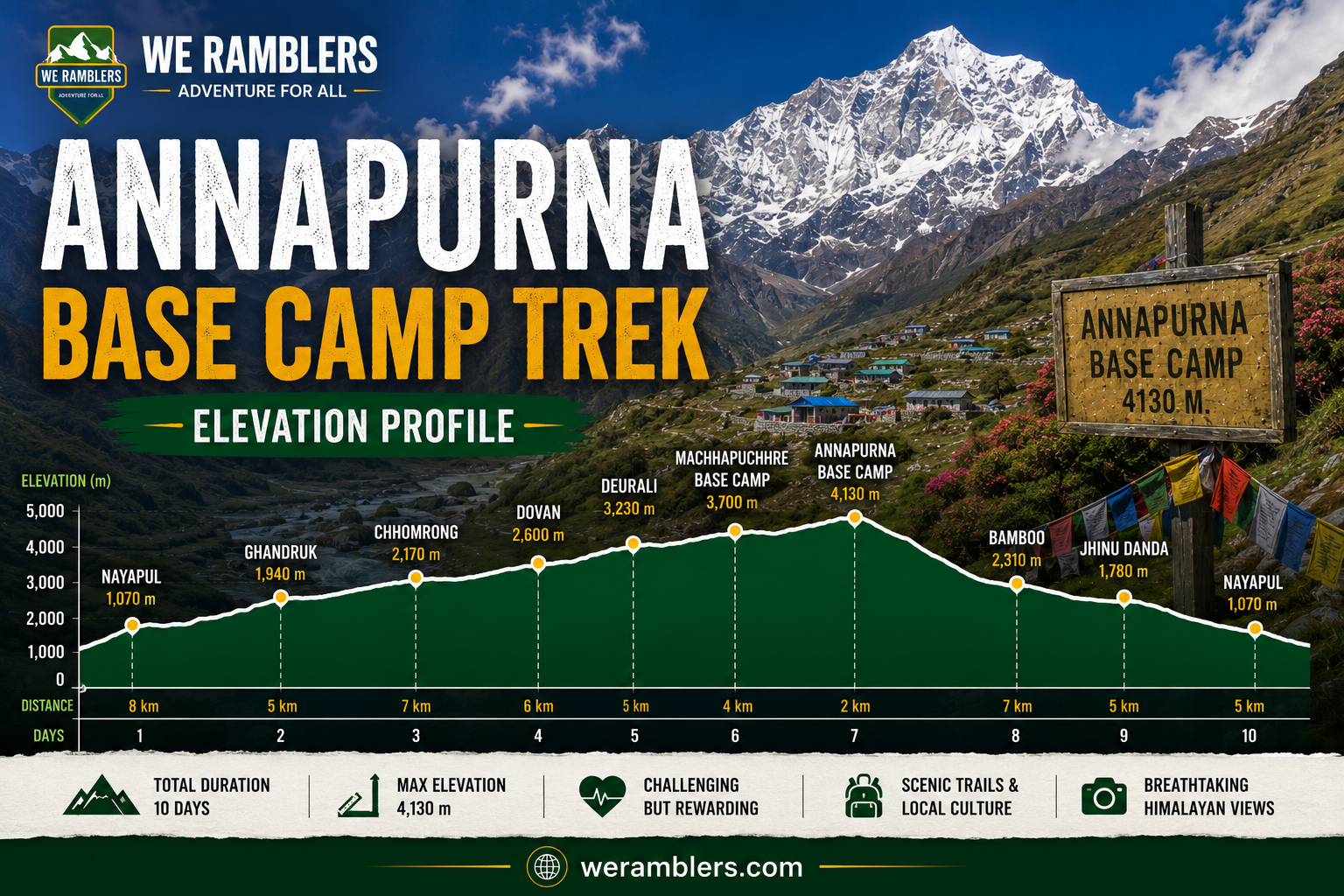
Unlike some high altitude treks that follow a fairly linear climb, the Annapurna Base Camp trek elevation profile is full of natural ups and downs. The trail weaves through deep river valleys, climbs over ridgelines, and drops back down before rising again toward the base camp itself. This rolling terrain is actually one of the reasons the trek feels so varied and scenic compared to other Himalayan routes.
Here is a general overview of the elevation profile you can expect along the classic route:
Pokhara (820 meters)
Most treks begin with a drive or short journey from Pokhara, which serves as the main gateway to the Annapurna region.
Nayapul to Tikhedhunga (1,540 meters)
The trek typically starts here, with a gentle to moderate walk through farmland and small villages.
Ghorepani (2,860 meters)
A significant climb up thousands of stone steps leads to this popular village, often paired with a sunrise hike to Poon Hill.
Poon Hill (3,210 meters)
A short early morning climb rewards trekkers with panoramic views of the Annapurna and Dhaulagiri ranges.
Chhomrong (2,170 meters)
The trail descends again before continuing toward the inner sanctuary, marking the gateway village to the Annapurna Sanctuary.
Bamboo (2,310 meters) and Dovan (2,600 meters)
The path drops into a forested valley filled with bamboo and rhododendron trees.
Deurali (3,230 meters)
The elevation begins climbing more steadily as you approach the high alpine zone.
Machhapuchhre Base Camp (3,700 meters)
Named after the sacred fishtail shaped peak, this is the last stop before the final push.
Annapurna Base Camp (4,130 meters)
The final destination, surrounded by a dramatic natural amphitheater of towering peaks.
This zigzagging elevation profile, with its mix of ascents and descents, is intentional. It allows trekkers to gain altitude gradually while still covering meaningful distance each day, reducing the physical shock that comes from rapid elevation gain.
Annapurna Base Camp Elevation Gain
When people ask about the Annapurna Base Camp elevation gain, they are usually referring to the total increase in altitude from the starting point to the final destination. Starting around 1,540 meters at Tikhedhunga and finishing at 4,130 meters at Base Camp, trekkers gain roughly 2,590 meters over the course of the trek.
However, because the trail includes several descents along the way, the actual cumulative elevation gain is higher than this simple start to finish calculation suggests. When you factor in the ups and downs through Ghorepani, Chhomrong, and the forested sections near Bamboo and Dovan, the total elevation gain can exceed 4,000 meters when measured cumulatively.
This is an important distinction because it affects how tired your legs will feel by the end of each day, even on days where the net elevation change seems modest on paper.
Annapurna Base Camp Trek Elevation Profile Difficulty
The Annapurna base camp trek elevation profile difficulty is often described as moderate, making it a great option for trekkers who want a genuine Himalayan experience without the extreme demands of treks that climb above 5,000 meters.
That said, several elements of the elevation profile contribute to the overall difficulty level.
Stone Staircases
The climb up to Ghorepani involves thousands of stone steps, which can be tough on the knees and lungs, especially for those unaccustomed to sustained uphill walking.
Repeated Ascents and Descents
Unlike a steady climb, this trek requires trekkers to go up and down repeatedly, which can be more physically demanding than a single continuous ascent covering the same net elevation.
Final Push to Base Camp
The last section from Machhapuchhre Base Camp to Annapurna Base Camp involves a noticeable increase in elevation over a short distance, often leaving trekkers slightly breathless.
Weather and Terrain Changes
As you climb higher, the terrain shifts from subtropical forest to alpine landscape, and temperatures can drop significantly, adding another layer of physical challenge.
Despite these factors, the Annapurna Base Camp trek remains accessible to most reasonably fit individuals, including those with limited high altitude trekking experience. With proper pacing and preparation, the moderate difficulty level makes it an excellent choice for adventurous beginners.
Annapurna Base Camp Trek Distance
The total Annapurna Base Camp trek distance is approximately 110 kilometers round trip, depending on the specific route and starting point chosen. This includes the journey to Base Camp and the return trip back to the trailhead.
On average, trekkers cover between 10 to 15 kilometers per day, though this varies based on terrain difficulty and elevation changes. Days involving steep climbs, such as the ascent to Ghorepani, often feel more demanding than flatter sections despite covering similar distances.
Most itineraries are structured over 7 to 12 days, allowing trekkers to cover this distance at a comfortable pace while still leaving room for rest and acclimatization.
Annapurna Base Camp Altitude Sickness
One of the most common concerns among trekkers is Annapurna Base Camp altitude sickness. While the maximum altitude of 4,130 meters is lower than many other Himalayan treks, altitude sickness can still occur, particularly if trekkers ascend too quickly or skip proper acclimatization.
Common symptoms of altitude sickness include:
- Headaches
- Nausea or loss of appetite
- Dizziness or lightheadedness
- Fatigue beyond normal trekking tiredness
- Difficulty sleeping
- Shortness of breath during mild exertion
The good news is that because the Annapurna Base Camp trek elevation profile includes natural ascents and descents, trekkers naturally get some acclimatization benefit built into the route itself. However, this does not eliminate the need for caution.
To reduce the risk of altitude sickness, trekkers should:
Drink plenty of water throughout each day, since dehydration can worsen symptoms significantly. Walk at a steady, unhurried pace rather than rushing between villages. Avoid alcohol consumption during the trek, particularly at higher elevations. Eat regular, energy sustaining meals even if appetite decreases. Communicate any symptoms to guides immediately rather than pushing through discomfort.
If symptoms become severe, the safest course of action is always to descend to a lower elevation and seek medical attention if necessary. At We Ramblers, our experienced guides are trained to recognize early signs of altitude sickness and know how to respond appropriately to keep trekkers safe.
Is Annapurna Base Camp Trek Safe?
A common question among first time trekkers is Is Annapurna Base Camp trek safe? The short answer is yes, when approached with proper preparation, a sensible itinerary, and an experienced guide service.
Several factors contribute to the overall safety of this trek:
Moderate Altitude
Compared to treks that climb above 5,000 meters, the lower maximum elevation of 4,130 meters reduces the risk of severe altitude related illness.
Well Established Trail
The route is well marked, frequently traveled, and supported by a strong network of teahouses offering food, accommodation, and emergency assistance along the way.
Reliable Infrastructure
Unlike more remote trekking routes, the Annapurna region has good mobile connectivity in many areas, along with accessible evacuation points if needed.
Experienced Guide Support
Trekking with a knowledgeable guide significantly increases safety, as they can help with pacing, weather awareness, and recognizing early warning signs of altitude sickness or fatigue.
Of course, no trek is entirely without risk. Weather conditions can change quickly in the mountains, and trekkers should always be prepared with appropriate gear, travel insurance, and a flexible mindset. Choosing a reputable trekking company like We Ramblers, with experienced local guides who know the terrain and elevation profile intimately, is one of the best ways to ensure a safe and successful journey.
Tips for Handling the Elevation Profile Successfully
To make the most of your trek and manage the elevation changes comfortably, keep these practical tips in mind.
Pace yourself on the stone staircases, especially the long climb toward Ghorepani, since rushing increases fatigue and the risk of injury. Use trekking poles to reduce strain on your knees during both ascents and descents. Layer your clothing appropriately, since temperatures shift noticeably as you move between forested lower elevations and the alpine zone near Base Camp. Take rest breaks as needed rather than pushing through exhaustion. Trust your guide’s judgment regarding pacing and acclimatization, particularly during the final approach to Annapurna Base Camp.
Following these simple strategies, combined with a well designed itinerary, makes the elevation changes far more manageable and enjoyable.
Ready to Explore the Annapurna Sanctuary?
Understanding the Annapurna Base Camp trek elevation profile gives you a solid foundation for planning a safe and rewarding adventure. From elevation gain and trek distance to difficulty and altitude sickness prevention, every detail plays a role in how your journey unfolds.
At We Ramblers, we specialize in crafting well paced, safe, and memorable trekking experiences throughout the Annapurna region. Our experienced local guides understand the elevation profile, the terrain, and the best practices for managing altitude, ensuring you reach Base Camp feeling strong and accomplished.
Visit weramblers.com today to explore our Annapurna Base Camp trek packages, check upcoming departure dates, and connect with our team to build an itinerary tailored to your fitness level and travel goals. The stunning amphitheater of peaks at Annapurna Base Camp is waiting, and we would be honored to guide you there.
Frequently Asked Questions: Annapurna Base Camp Trek Elevation Profile
What is the highest point on the Annapurna Base Camp trek elevation profile?
The highest point is Annapurna Base Camp itself, sitting at approximately 4,130 meters above sea level.
How much elevation gain should I expect on this trek?
Trekkers typically experience a net elevation gain of around 2,590 meters from the starting point, though cumulative gain including ascents and descents can exceed 4,000 meters.
Is the Annapurna Base Camp trek suitable for beginners?
Yes, with a moderate difficulty level and a lower maximum altitude than many other Himalayan treks, it is considered accessible for reasonably fit beginners.
How can I avoid altitude sickness on this trek?
Stay hydrated, walk at a steady pace, avoid alcohol, eat well, and follow your guide’s advice regarding acclimatization and pacing.
What is the best season to trek to Annapurna Base Camp?
Spring, from March to May, and autumn, from September to November, offer the most stable weather and clearest mountain views.
If you have questions about the trek or want personalized guidance on choosing the right itinerary for your fitness level, feel free to reach out to the We Ramblers team anytime.